
High Resolution Semantic Change Detection Dataset
The Dataset
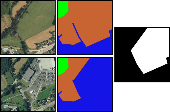
This dataset contains 291 coregistered image pairs of RGB aerial images from IGS’s BD ORTHO database. Pixel-level change and land cover annotations are provided, generated by rasterizing Urban Atlas 2006, Urban Atlas 2012, and Urban Atlas Change 2006-2012 maps.
The dataset is split into five parts:
- 2006 images
- 2012 images
- Change labels
- 2006 land cover maps
- 2012 land cover maps
The 2006 images are under a non-redistributable licence, but can be downloaded directly from IGN’s website.
Update as of 2023: All data can now be downladed from DataPort.
Labels
Change labels are available for all image pairs in the dataset. Available classes:
- 0: No change
- 1: Change
Land cover maps are available for all images in the dataset. Urban Atlas classes have been grouped at first hierarchical level, as described in the paper cited above. Available classes:
- 0: No information
- 1: Artificial surfaces
- 2: Agricultural areas
- 3: Forests
- 4: Wetlands
- 5: Water
References
If you use this work for your projects, please take the time to cite our paper:
[ScienceDirect] [Preprint] [PDF] [BibTeX]
Links
You can download the dataset on IEEE DataPort webpage:
- https://ieee-dataport.org/open-access/hrscd-high-resolution-semantic-change-detection-dataset
- Please contact me if you need help finding the 2006 images.
Copyright
The images in this dataset are released under IGN’s “licence ouverte”. More information can be found at http://www.ign.fr/institut/activites/lign-lopen-data
The maps used to generate the labels in this dataset come from the Copernicus program, and as such are subject to the terms described here: https://land.copernicus.eu/local/urban-atlas/change-2006-2009?tab=metadata
This dataset is released under Creative-Commons BY-NC-SA licence. For commercial purposes, please contact the authors.
The Team
- Rodrigo Caye Daudt, rcayedaudt@ethz.ch
- Bertrand Le Saux, bls@ieee.org
- Alexandre Boulch, alexandre.boulch@valeo.com
- Yann Gousseau, yann.gousseau@telecom-paris.fr